Alaska tour
Table of Contents
Anchorage to Seward mile-stops
Kenai Fjord Tours in Kenai fjords
Cruise - The 26 Glacier Cruise Experience
Overview
|
Day |
What |
City to sleep in |
|
Day 0 |
Fly to Anchorage in evening |
Anchorage |
|
Day 1 |
Travel from Anchorage to Seward, stop
for attractions on the way |
Seward |
|
Day 2 |
Cruise with "Kenai Fjord
Tours" in Kenai fjords - all day trip |
Seward |
|
Optional |
Dog sledging or from Alyeska |
Seward |
|
Day 3 |
Travel from Seward to Whittier, stop for
attractions on the way |
Alyeska |
|
Day 4 |
1/2 day trip in Prince William Sound |
Alyeska |
|
Optional |
Dog sledging or from Seward |
Alyeska |
|
Day 5 |
Travel from Anchorage to Denali, stop
for attractions on the way (goldmine...) ; |
Denali |
|
Day 6 |
Tour/hike in Denali National Park |
Anchorage |
|
Optional |
Bear viewing - flight |
Anchorage |
|
Day 7 |
Fly back to Seattle in evening |
|
Day 1
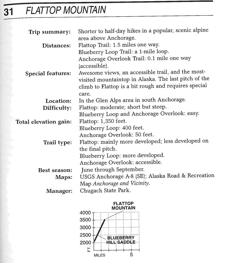
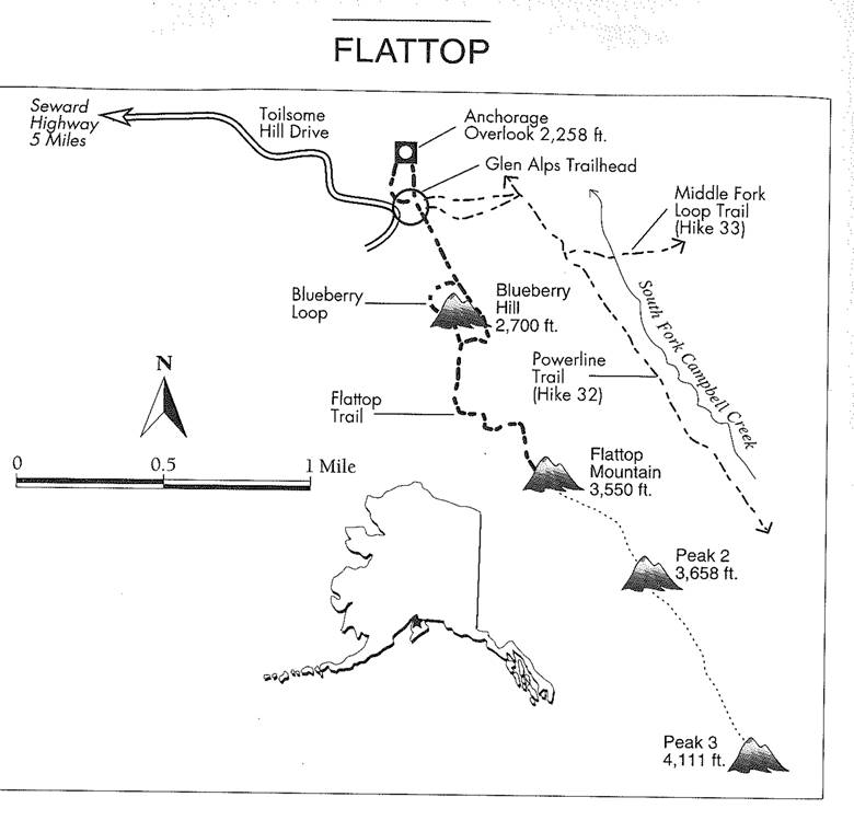
· Flattop mountain
o Drive to overlook
o Pick a hike maybe blueberry hill
· Drive to Seward
· Choose which mile-stops to do along the way. Recommended stops
o Potter Marsh
o Indian Valley Mine
o Bird creek (see people fishing)
Flattop Mountain
Anchorage to Seward mile-stops
POTTER SECTION HOUSE (Mile 117)
The area is part of the Anchorage
Coastal Wildlife Refuge and is mainly famous for the many kinds of birds that
live there or visit, but you may also see fish and other wildlife. On the south
side of the higway just past the marsh is an old station of the Alaska Railroad
which you may enjoy, especially if you are interested in trains.
POTTER SECTION HOUSE (Mile 115)
Located at the south end of Potter Marsh, the section house was an
early maintenance station for the Alaska Railroad. Today it contains the offices
of Chugach State Park, open during normal business hours, and, outside, a few
old train cars and interpretive displays. Just across the road is the trail
head for the Turnagain Arm Trail. It's a mostly level path running down the arm
well above the highway with great views breaking now and then through the
trees. Hike as far as you like and then backtrack to your car, or continue 9
miles to Windy Corner (if you can have a vehicle waiting for you there), or
break off where the trail meets the McHugh Creek picnic area and trailhead,
about 4 miles out.
McHUGH CREEK (Mile 111)
Four miles south of Potter is an excellent state park picnic area
and a challenging day hike with a 3,000-foot elevation gain to Rabbit Lake,
which sits in a tundra mountain bowl, or to the top of 4,301-foot McHugh Peak.
You don't have to climb all the way; there are spectacular views within an hour
of the road. From this point onward, most of the stops are on the right or
ocean side of the road; plan your stops on the outbound trip, not on the return
when you would have to make left turns across traffic.
BELUGA POINT (Mile 110)
The state highway department probably didn't need to put up scenic
overlook signs on this pull-out, 11/5 miles south of McHugh Creekyou would
have figured it out on your own. The terrain is simply awesome, as the highway
traces the edge of Turnagain Arm, below the towering cliffs of the Chugach
Mountains. If the tide and salmon runs are right, you may see beluga whales,
which chase the fish toward fresh water. Sometimes they overextend and strand
themselves by the dozens in the receding tide, farther along, but they usually
aren't harmed. The pull-out has spotting scopes to improve the viewing. The
further right-hand pull-outs over the next few miles have interpretive signs
about the 1895 gold rush in this area and other topics.
WINDY POINT (Mile 106)
Be on the lookout on the mountain side of the road for Dall sheep
picking their way along the cliffs. It's a unique spot, for the sheep get much
closer to people here than is usual in the wild; apparently, they know they're
safe. Windy Point is the prime spot, but you also have a good chance of seeing
sheep virtually anywhere along this stretch of road. If cars are stopped,
that's probably why; get well off the road and pay attention to traffic, which
will still be passing at high speeds. You may also see windsurfers in the gray,
silty waters of the Arm. They're crazy. The water is a mixture of glacial
runoff and the near-freezing ocean. Besides, the movement of water that creates
the huge tides causes riverlike currents, with standing waves like rapids.
INDIAN VALLEY (Mile 104)
Up the road by the Turnagain House restaurant is the Indian Valley
trail head, a gold rushera trail that ultimately leads 24 miles to the other
side of the mountains. The path, while often muddy, rises less steeply than
other trails along the Arm.
BIRD RIDGE TRAIL (Mile 102)
This is a lung-busting climb of 3,000 vertical feet in a little
over a mile. It starts with an easy, accessible trail, then rises steeply to
views that start at impressive and get more amazing as you climb. With the
southern exposure, it's dry early in the year.
BIRD CREEK (Mile 100)
The excellent state campground on the right side of the highway,
over the water, is described on p. 255, and the productive salmon fishing in
the creek is described on p. 255. Anglers should park at the new wayside on the
left before the creek. There is also a short trail, interpretive signs, an
overlook, and a platform that makes fishing easier for people with
disabilities. Pink salmon run from late June to mid-August, silver salmon
mostly in August.
BIRD POINT (Mile 96) The remarkable wayside here is
not to be missed. A paved pathway rises up to a bedrock outcropping with a
simply wonderful viewall the severity of the Turnagain Arm, but framed by the
soft green of a freshwater wetland with a beaver lodge. Take a look at the
fascinating interpretive signs on many subjects.
THE FLATS (Miles 9690)
At Bird Point the highway descends from the mountainside to the
mud flats. A fragment of bike trail parallels the highway on the mountain for
this 6 miles with picnic sites along the way and great views. Several pull-outs
on the right side of the highway have Interpretive signs. At hightide, water
comes right up to the road. At low tide, the whole Arm narrows to a thin,
winding channel through the mud. The Arm is not practically navigable and
navigational charts are not even available. Few have ever tried to navigate it
other than gold prospectors in rowboats a century ago or today's occasional
death-defring canoeist or kayaker. The first to try was Capt. James Cook, in
1778, as he was searching for the Northwest Passage on his final, fatal voyage
of discovery (he was killed by Hawaiians later that year). He named this branch
of Cook Inlet Turnagain Arm because the strength of the currents and shoals
forced the boat he sent to keep turning around.
TURNOFF TO GIRDWOOD (Mile 90)
The attractions ofGirdwood, covered below, are worth a visit, but
the shopping center here at the intersection is not chief among them. Stop for
a simple meal or a restroom break, or to fill your gas tank for the last time
for many a mile.
OLD PORTAGE (Mile 80)
All along the flats at the head of Turnagain Arm are large marshes
full of what looks like standing driftwood. These are trees killed by salt
water that flowed in when the 1964 quake lowered the land as much as 10 feet.
On the right, 9 miles beyond the turnoff for Girdwood, across from the former
rail depot, a few ruins of the abandoned town of Portage are still visible, 40
years after the great earthquake. There is good bird-watching from the
turnouts, but venturing out on Turnagain Arm's tidal mud carries the real risk
of getting stuck in quick sand like mud and drowning in the tide. Don't do it.
ALASKA WILDLIFE CONSERVATION CENTER (Mile 79)
Originally conceived as a tourist attraction (formerly it was
called "Big Game Alaska"), the center has become a non-profit
organization giving homes to injured and orphaned deer, moose, owls, elk,
bison, musk ox, bear, fox, and caribou (907/ 783-2025). Visitors can drive a
short course on the 140-acre compound to see the animals in fenced enclosures
as large as 18 acresat times, some animals are not visible among the natural
vegetation. You can usually get closer to the animals at the Alaska Zoo and see
a larger variety (p. 219), but these large enclosures are more natural. A large
log gift shop and outdoor snack bar is at the end of the tour. Admission is
$7.50 for adults; $5 for military, seniors, and children 4 to 12, with a
maximum of $25 per vehicle. In summer, it's open daily from
8am to 8pm; in winter, daily from loam to 5pm.
PORTAGE GLACIER (Take the 511-mile spur road at Mile 78)
The named attraction has largely melted, receding out of sight of
the visitor center. (The glacier you can see is Burns.) When the center was
built in 1985, it was predicted that Portage Glacier would keep floating on its
800-foot-deep lake until 2020. Instead, it withdrew to the far edge of the lake
in 1995. Today the exhibits in the lakeside BegichBoggs Visitor Center focus
on the Chugach National Forest as a whole, rather than just the glacier, and
they're worth an hour or two to become oriented to the area's nature, history,
and lifestyles. Children and adults find much to hold their interest here. To
see Portage Glacier itself, take the road toward Whittier that branches to the
left just before the visitor center and stop at a pullout beyond the first
(toll-free) tunnel; or take the boat mentioned below. Several short trails
start near the center. Rangers lead nature walks on the quarter-mile, paved
Moraine Trail up to six times a day. Another trail leads less than a mile to
Byron Glacier, in case you're interested in getting up close to some ice.
Always dress warmly, as cold winds are the rule in this funnel-like valley.
MILE 7569
The highway steeply climbs through the spruce forest to the fresh,
towering alpine terrain of the 1,000-foot-elevation Turnagain Pass. The vistas
here are stupendous year-round.
MILE 69
If you find the meadow and tundra hard to resist for a walk, go
ahead. Park at the pull-out with the toilets on the right side at the pass
summit and amble off into the wildflowers (assuming the ground is dry when
you're there). In the winter and spring, this is a backcountry skiing and
snowmobiling paradise. Skiers go on the left side of the road and snowmobilers
on the right. Always check the Chugach National Forest avalanche hotline first:
907/ 754-2369 or www.fs.fed.us/r10/chugach/glacier/snow.html.
An avalanche near here killed five riders in spring 1999.
MILE 6957
The pass forms a divide; crossing it, Granite Creek flows down
toward the south. The road follows, falling back below the tree line of stunted
spruce and then popping back up into sweeping views. Arcing to the northwest
after the Granite Creek Campground, the highway follows another north-flowing
river, Six-Mile Creek.
MILE 57 & HOPE HIGHWAY
The Hope Highway divides offto the north and west along Sixmile
Creek while the Seward Highway continues south. Rafting companies based in
Anchorage use this wild stretch of water for some of their most challenging
rides (see chapter 6). A Side Trip to Hope If you take this detour, you'll find
Hope at the end of the 17-mile Hope Highway. It's a charming gold rushera
village with a wonderful campground and the starting point for some great hikes
(see the Resurrection Pass Trail, p. 248, and Porcupine Campground, p. 251). A
few white frame buildings remain from the days when Hope was a gold-mining
boomtown after a strike in 1894. Before the 1964 earthquake, the rest of the
town used to stand where the creek gives way to a tidal meadow. Wandering the
gravel roads, you'll find more quaint spots. Today, Hope's year-round
population is about 150. For information, contact the HopeSunrise Community
Library (907/782-3121), which is open daily in summer from 11am to 4pm, when
volunteer manpower allows. The Hope and Sunrise Historical and Mining Museum
(907/782-3740) is a one-room log cabin displaying historic objects and
photographs, a barn, blacksmith's shop and miner's bunkhouse. They're trying to
open the old school building by 2005. Volunteers try to keep the museum open
Memorial Day to Labor Day daily noon to 4pm. The best place to eat in town is
the Discovery Cafe (C) 907/782-3274), the community's hub and a place to get a
generous burger and meet the beloved proprietor. The cafe burned to the ground
in 1999 and was rebuilt almost entirely by volunteer labor, reopening in the
summer of 2001.
MILE 5746 The Seward Highway climbs steeply from the
Hope Highway intersection, up the canyon of Canyon Creek, before leveling out
above the tree line at about 1,400 feet elevation. Next come a series of alpine
lakes in a narrow mountain valley.
MILE 46
The first business since the Portage Glacier, and the last or many
miles, is on lovely Summit Lake, the Summit Lake Lodge, at Mile 45.5 ((0
907/244-2031). It's a traditional log roadhouse that's been updated to house a
comfortable and modern restaurant. The food is generally good, but service can
suffer badly when weekend highway travelers overwhelm the staff. There's an ice
cream counter in the log gift shop by the lake and they rent six motel rooms
with private bathrooms, but without TVs or phones.
MILE 4638
The highway continues through similar mountain terrain before
descending into the trees again and branching at Tern Lake. There's a
bird-watching platform with interpretive signs on the lake and, on the west
end, a picnic area. This is a stirringly beautiful spot year-round, and a good
place to get out and taste the fresh mountain air. To the right at the
intersection, the Sterling Highway leads to Cooper Landing, Soldotna, Kenai and
Homer.
MILE 3318
Trail Lake Fish Hatchery, on Upper Trail Lake, is on the first of
a string of sparkling mountain lakes that the road follows for the next 15
miles.
MILE 30
The community of Moose Pass, with a population of about 200, sits
on the shore of Upper Trail Lake.
MILE 180
Down among the big spruces of the coastal forest, the highway
comes to Seward.
Day 2
· Exit glacier hike (Harding icefield trail will be done next day)
· Kenai Fjord Tours
EXIT GLACIER
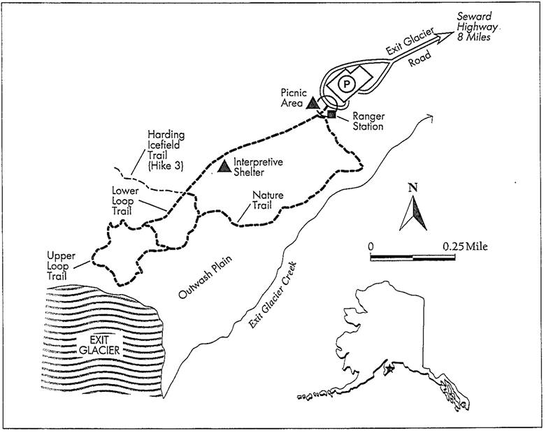
Trip summary: Three
shorter trails for day hiking near the face of Exit Glacier, the only drive-up
glacier in Kenai Fjords National Park.
Distances:
·
The Lower Loop
"frail, to the outwash plain near the face of the glacier: a 0.5-mile
loop.
·
The Upper Loop
Trail, to a viewpoint above the north edge of the glacier: a 1-mile loop.
·
The Nature Trail,
a loop through the landscape left behind as the glacier retreated: a 0.75-mile
loop.
Special features: Exit
Glacier; a shelter with an interpretive display.
Location: 12 miles
northwest of Seward.
Difficulty: Easy.
Total elevation gain: About
100 feet on the Upper Loop Trail; the Lower Loop Trail and Nature Trail are
essentially flat.
Trail type: Accessible
to more developed.
Best season: Mid-May
to early October.
Manager: Kenai Fjords
National Park.
Finding the trailhead:
Three miles north of downtown Seward, turn west off the Seward Highway onto
Exit Glacier Road and drive about eight miles to the Exit Glacier area of Kenai
Fjords National Park. The trails begin at the parking area at the end of the
road.
About 7 miles from the Seward Highway, just before the
bridge over Resurrection River, is the Forest Service's Resurrection River
Trailhead (see Hike 9).
The hikes: Exit
Glacier, the only road-accessible area in Kenai Fjords National Park, is one of
the thirty-five glaciers that flow off the 500-square mile Harding Icefield.
The glacier is now approximately 3 miles long, but in the past two hundred
years it has extended about eight miles down the Resurrection River valley to
near where the Seward Highway is now.
These three short trails introduce visitors to Exit Glacier
and the landscape it left behind as it retreated. The first 0.25 mile of the
trail system is paved and accessible, leading to an interpretive shelter that
features displays about the glacier and the animals that live in the
neighborhood. Beyond the shelter, the three forks of the trail system divide.
Walking all the trails adds up to roughly 1.5 miles.
There is a seasonal ranger station near the trailhead and a
small, tent only campground nearby. In summer, the park sponsors ranger-led
hikes to the glacier.
The Lower Loop
Trail leads about 0.25 mile beyond the interpretive shelter to the face of the
glacier, crossing its outwash plain, the flat gravelly area downstream of the
terminus of the ice. A jumble of giant chunks of blue ice looms ahead as you
stroll along near the edge. For safety's sake, keep your distance from the ice.
Several years ago a visitor was killed by
falling ice as she posed for a photo.
The Upper Loop Trail
leads from the interpretive shelter up rock and log steps and over exposed
bedrock to a viewpoint above the north edge of the glacier. The reward for the
short climb is a view down onto the ice, of a stream issuing out of the
glacier, a big melt pool, and ice caves. The trail loops back down to the Lower
Loop Trail and the parking area. The Nature Trail forms a 0.75-mile loop from
the parking area. Signs explain how plants colonize the raw land left behind as
a glacier retreats. Here, natural succession from bare outwash plain to forest
moves through stages of brightly-blooming fireweed, alder and willow thickets,
cottonwood forest, and finally a "climax" forest of Sitka spruce and
western hemlock.
Already a few spruce trees are beginning to grow up in the
shade of the young cottonwoods along the trail. In time, this will be an
evergreen forest. While exploring the Exit Glacier area, look to the north of
the glacier for black bears and mountain goats feeding on the brushy slope.
You're more likely to spot animals here early in the summer; they follow the
retreating snowline up, feeding on new green growth as it emerges. Look and
listen for warblers, magpies, swallows, and golden-crowned sparrows near the
trails.
The trail to the Harding Icefield overlook (Hike 3)
branches off the trails to Exit Glacier. The Exit Glacier trails are open to
foot and wheelchair traffic only, and no pets are allowed.
This is Alaskas most popular wildlife and glacier cruise!
We depart from Seward, Alaska, and provide an in-depth experience of Kenai
Fjords National Parks abundant wildlife, alpine and tidewater glaciers.
Tours are fully narrated by our experienced captains and
include a visit to the Alaska Maritime National Wildlife Refuge, home to
teeming seabird rookeries.
Kenai Fjord Tours in Kenai fjords
Website: http://www.kenaifjords.com/day-cruises/national-park-tour/#10am
Time: 10:00 AM - 6:30
PM (8.5 hours)
Includes:
·
Lunch on board (view menu)
·
Buffet-style wild
Alaska salmon and prime rib for dinner (view menu)
· A warm, freshly baked chocolate chip cookie
· Courtesy shuttle in Seward
· FREE parking in Seward (a $10 value)
Extra
· We paid for the Alaska king crab
Reference number: RP33970
Cancellation: Up to 15
days before trip
Cost: 346.63 (includes
a 12.50 king crab each)
Contact info:
·
1-800-544-0529 Toll
Free
·
907-276-8023 Phone
Office Hours:
·
Summer, Daily,
7:00 am 10:00 PM
·
Winter, Monday -
Friday, 8:00 am 5:00 PM
Day 3
Try making reservations at the Alyeska resort (great hotel)
· Harding icefield hike
· Winner Creek Trail hand tram
· Optional Alyeska resort Aerial tramway (since you staying there if you have time you can do it)
HARDING ICEFIELD
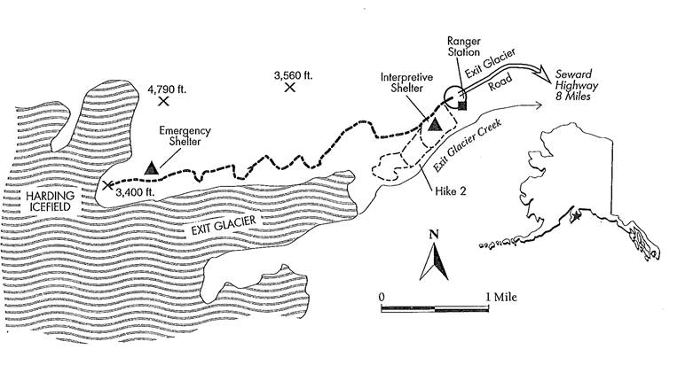
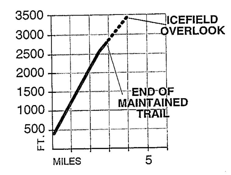
Trip summary: A longer
day hike from Exit Glacier to an overlook of the Harding Icefield.
Distance: About 4
miles one way.
Special features: Exit
Glacier and the Harding Icefield, great views and wildlife, especially mountain
goats. There is an emergency shelter on the trail just below the overlook.
Location: 12 miles
northwest of Seward.
Difficulty: Moderately
strenuous.
Trail type: More
developed trail with a few rough, rocky spots; the last 0.75 mile is a less
developed trail/marked route.
Total elevation gain: 3,000
feet.
Best season: July to
mid-September, though snow lingers all summer.
Manager: Kenai Fjords
National Park.
Key points:
·
1.5 Viewpoint,
about 1,600 feet elevation.
·
2.5 Viewpoint,
about 2,600 feet elevation.
·
3.25 End of the
constructed/maintained trail.
·
4.0 Harding
Icefield overlook.
Finding the trailhead:
The directions are the same as those to Exit Glacier, Hike 2. From the parking
area, follow the paved access trail about 0.25 mile to the interpretive
shelter. Just beyond the shelter, turn right onto the
Harding Icefield Trail.
The hike: Start early,
and pack a camera and plenty of film for this hike to the edge of the Harding
Icefield, where dark peaks thrust out of a sea of ice. The trail climbs through
forest and brush, alpine wildflower meadows, and finally rock and snow, to the
overlook. The switchbacking grade is gradual, courtesy. of the Student
Conservation Association. The SCA's high school trail workers, hailing from all
over the country, have worked for several years to build this spectacular
trail. Fog, rain, and poor visibility are common, and weather can change
quickly, so carry warm, waterproof clothes even on sunny days. Be prepared to
retreat if bad weather moves in; you probably couldn't see anything anyway. If
the weather is decent, be ready to be amazed.
From the Exit Glacier parking area, pick out the route on
the sloping ridge between Exit Glacier and the rocky peaks to the north. The
trail crosses a small creek and leads over a rough, rocky stretch where the
route crosses a large outcrop. The viewpoint at 1.5 miles is on a brushy knob
above treeline; the view at 2.5 miles, in a rocky alpine area, is better.
The last 0.75 mile is an unmaintained route beaten by many
feet over snow and loose rockf following a lateral moraine and exposed bedrock
above Exit Glacier. There is a shelter below the overlook that is for emergency
use only. Camping near the icefield is possible but limited; if you do camp
here, please camp on bare rock or snow and not on the sparse, easily-damaged
vegetation. Most people will find it better to tent at the small campground
back on the park road and carry a lighter day pack up the climb to the
icefield. Remember that glacier travel is for the experienced and equipped
only.
Mountain goats are fairly common in the high country. Look for
black bears, especially earlier in the summer, when they munch on new green
plant growth. The trail is for foot traffic only, and no pets are allowed.
If the park budget hasn't been slashed lately, Kenai Fjords
staff offer ranger-led hikes to the icefield. Check at the park visitor center
in Seward or at the ranger station at Exit Glacier for availability and times.
Shorter hikes. The
viewpoints at 1.5 and 2.5 miles make good turnaround points for shorter day
hikes. The distance, grade, and the rocky section early in the hike make this a
less appealing trail for smaller children.
Winner Creek Trail hand tram
The easiest/shortest access to the trail is from Crow Creek Rd. and park near (not in) the Crow Creek Mine. The mine is 2.7 miles from the start of Crow Creek Rd. If it's been raining this trail can be messy/muddy. From the trail entrance (just inside of Crow Creek Mine's entrance) it's about a 20 to 30 minute walk to the tram.
See:
· alaskahikesearch.com/hikes/winner-creek/ (see "To start from the mine end:")
· www.alaska.org/detail/winner-creek-trail
Day 4
· 1/2 day cruise in Prince William Sound - Need to cross the tunnel. To pass the tunnel, it goes for 15 min every hour on the halves toward the cruise and every hour on the hour going back.
· (If you doing the optional dog sledging you can do it next day as well) - Alyeska aerial tram (The tickets are for all day and you can go any numbers of times. I got the tickets for free as part of the reservation and gave mine to the next person when I went down. If you didnt get them maybe somebody will give it to you).
Cruise - The 26 Glacier Cruise Experience
The 26 Glacier Cruise travels over 140 miles into Prince
William Sound where you will see 26 named glaciers and many more unnamed. We
get face to face with these towering masses of ice, so close you can hear the
glaciers move and gaze at their brilliant blue hues.
On the 26 Glacier Cruise, you'll see several types of
glaciers, including Alpine (hanging), Piedmont and Tidewater. Glacier calvings
(when broken pieces of ice fall into the water and become icebergs) are
normally seen on each cruise.
M/V Klondike Express
The Klondike Express is the largest, fastest and most
luxurious catamaran in Alaska.
This 137-foot, high-speed catamaran holds 338 passengers
on three decks, two of which are enclosed and heated and there is an inside
seat and table for every passenger on board. During this 5-hour cruise, our
route covers 140 miles cruising through narrow passage ways, along jagged
shorelines, and down glacier carved fjords. In one day, guests can see 26
glaciers, as well as an abundance of wildlife in their natural environment. Cruise
face to face with towering masses of ice, so close that you can hear the
glaciers move. Gaze at the brilliant blue hues and towering spires of alpine,
piedmont and tidewater glaciers. If the timing is right, you may also get lucky
and witness a section of ancient ice calve into the sea. To witness this
massive movement of ice and hear its thunderous roar is truly an unforgettable
experience.
Highlights
Esther Passage, Barry Arm, Harriman Fjord
Explore over 140 miles of Prince William Sound
Cruise by a Stellar sea lion rookery
26 named glaciers and many more along this route
5 hours, daily May - September
Website: http://www.phillipscruises.com/
Time: 12:30 - 5:30
Includes: COD meal
Extra
·
Reference number: 206453
(spoke with Sara)
Cancellation: up to
8 days prior $25
Optional dog sledging
· Alyeska aerial tram (The tickets are for all day and you can go any numbers of times. I got the tickets for free as part of the reservation and gave mine to the next person when I went down. If you didnt get them maybe somebody will give it to you).
· Dog sledding - I took the Gridwood airport alpine
GLACIER DOG SLEDDING
This Alaskan adventure is hard to top! Take this exciting opportunity to learn about the dedicated dog sled teams of the Alaskan Huskies. Enjoy a spectacular helicopter ride into the majestic Chugach Mountains and onto Punch Bowl Glacier, 3200 feet above sea level. It is a giant snowfield on top of hundreds of feet of ice. Learn how the dogs are bred. Relax and enjoy the view as you ride on the sled around the glacier enjoying the scenic peaks and valleys surrounding you. See how the dogs are trained to pull the sled, how they have everlasting endurance, how they possess an inherent drive to run, and if you pull on the brakes its still hard to hold them back!
This is a trip you will NEVER forget, and most visitors say it was the highlight of their Alaskan vacation!!
Dog Sledding with Alaskan Huskies is such a large part of Alaskan life and history. The Iditarod Trail started out as a mail and supply route from the towns of Seward and Knik to the interior. Part of the Iditarod trail was used as a life saving highway for epidemic stricken Nome, where sled dogs were used to deliver Serum in 1925 to cure Diphtheria. It is now the famous Last Great Race on Earth where dogs, sleds and their mushers leave from Anchorage and race to Nome. Each team of a musher and 12-16 dogs embarks on a journey of 1150 miles over 10-17 days. For further information please see the following website: http://www.iditarod.com
If you have never followed this race before, after experiencing this tour, I know you will be in awe of this great race and sport!
Please dress in layers, expect temperatures on the glacier to be from 50°- 60°.
Wear warm comfortable clothing, sturdy shoes, and sunglasses.
We will provide you with a waterproof outer layer and Neos over-boots that you wear over your shoes.
Tours depart daily May 21st - Aug 31st
Our departure Times from Girdwood:
8:30am, 10:15am, 12:00pm, 1:45pm, 3:30pm, 5:15pm
This adventure is $519 per person. Child rate is $489, 12 & under. We require a reservation minimum of two.
We can pick you up and drop you off at various locations in Girdwood on request.
For additional information check our FAQs, to book your tour email us at info@alpineairalaska.com or call us at (907) 783-2360 and we'll gladly assist you with other questions or concerns.
See more at: http://www.alpineairalaska.com/glacier-dog-sledding_copy
Day 5
· Independence mine
· Talkeetna on the way to Denali (if its a sunny day, it will have a great view of Mt. Mckinley/Mt.Denali according to the new name J)
Independence mine
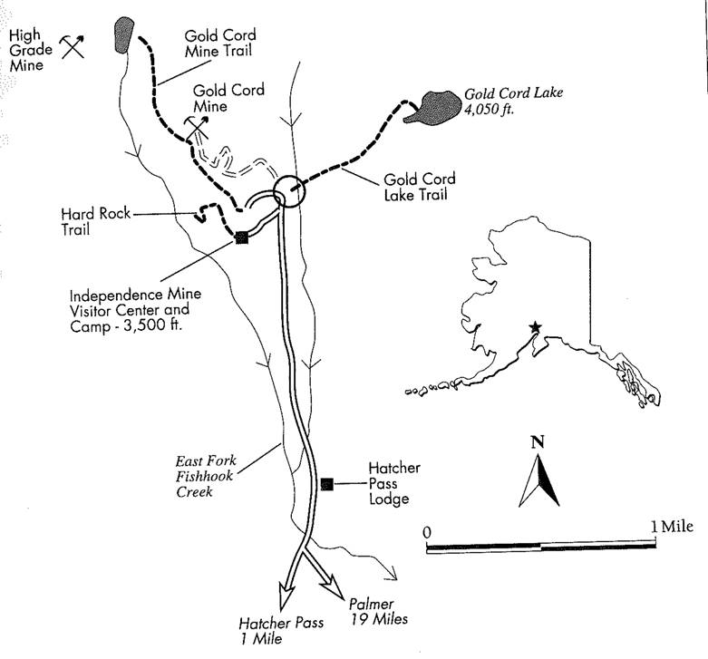
Trip summary: Shorter day hikes in the Independence Mine State Historical Park in the Talkeetna Mountains.
Distances:
·
The Hard Rock
Trail, 0.5 mile one way, an easy walking tour through a partially-restored
mining camp.
·
The Gold Cord Lake
Trail, 0.5 mile one way, a hike to an alpine lake.
·
The Gold Cord Mine
Trail, 1 mile one way, a hike to two historic mines.
Special features: Mining
history, alpine tundra, wildflowers, and rugged mountains. There is a day use
fee.
Location: 20 miles
north of Palmer.
Difficulty:
·
Hard Rock Trail:
easy
·
Gold Cord Lake
Trail: moderate
·
Gold Cord Mine
Trail: moderate.
Trail type:
·
Hard Rock Trail:
more developed.
·
Gold Cord Lake :
less developed.
·
Gold Cord Mine
trails: less developed.
Total elevation gain:
·
Hard Rock Trail:
100 feet
·
Gold Cord Lake:
600 feet.
·
Gold Cord Mine
trail: 600 feet.
Best season: Mid-June
to mid-September.
Manager: Alaska State
Parks, Matanuska-Susitna Area.
Finding the trailhead: Drive north of palmer on the Glenn
Highway to Fishhook-Willow Road, which is 2 miles north of the Palmer-Wasilla
Highway intersection in Palmer. west toward Hatcher Pass, and drive 17.3 miles
to Gold Cord Road. The last three miles beyond the Motherlode Lodge are fairly
steep. At Gold Cord Road, continue straight ahead as the road over Hatcher Pass
bears left. Drive past the Hatcher Pass Lodge on the right to the park entrance
station. The parking area is a mile beyond the entrance station on the left,
below the red-roofed visitor center.
The hikes:
The Independence Mine State Historical Park commemorates
the Alaska Pacific Consolidated Mining Company gold mines near Hatcher Pass the
second-richest lode (vein) mines in Alaska's history. The park's trails are all
alpine hikes, beginning at 3,500 feet elevation. Hikers can explore acres of
alpine tundra and check out the wildflowers that are out in
force by late June or early July.
more gradual climb follow the switchbacking Gold Cord Road
, now closed to vehicles, up to the Gold Cord Mine buildings. The trail joins
the dirt road at the buildings. Just beyond the Gold Cord camp, take the left
fork in the road gently uphill to the High Grade Mine cabin and to the small
tarn near the head of Fishhook Creek. Take some time to explore the old mining
trails in the rocky tundra, and enjoy the view across the Matanuska Valley to
the Chugach Mountains.
The visitor center is open daily from June to Labor Day,
and on weekends from Labor Day until mid-September. Take care around the
collapsing buildings and mine structures, and please don't disturb the
privately-owned Gold Cord and High Grade Mine buildings.
Day 6
· Denali bus (you might want to book the green bus ahead of time, I managed to get tickets the same day but you might not want to risk it). There is no real reason to go after Toklat stop.
Denali bus road log
A ROAD LOG
Here are some of the highlights along the road (check the visitor
center or the park service information handouts to confirm times of the guided
walks):
MILE 9
In clear weather, this is the closest spot to the park entrance
with a view of Mount McKinley. This section also is a likely place to see
moose, especially in the fall rutting season.
MILE 14
At the end of the paved road at the Savage River Bridge, this is
generally as far as private vehicles can go. A park service checkpoint stops
anyone who doesn't have a proper permit. From the parking lot by the bridge, a
simple climb over dry tundra leads to Primrose Ridge, also known as Mount
Wright.
MILE 17
The portable toilets here are as far as the Natural History Tour
bus goes.
MILE 29
An hour and 10 minutes into the drive, a large rest stop
overlooks the Teklanika River, with flush toilets, the last plumbing on the
road (until completion of the Eielson Visitor Center rehab). The Teklanika,
like many other rivers on Alaska's glacier-carved terrain, is a braided rivera
stream wandering in a massive gravel streambed that's much too big for it. The
braided riverbeds, sometimes miles wide, were created by water from
fast-melting glaciers at the end of the last ice age. Each is kept free of
vegetation by its river, which constantly changes course as it spreads the
debris of rock and dust from the glaciers. Flat plains in glacial terrain
usually are laid down by this mechanism.
MILE 34
Craggy Igloo Mountain is a likely place to see Dall sheep. Without
binoculars, they'll just look like white dots. Manageable climbs
on Igloo, Cathedral, and Sable mountains take off along the road in the section
from Igloo Creek to Sable Pass.
MILE 3843
Sable Pass, a critical habitat area for bears, is closed to
people. A half-eaten sign helps explain why. Bears show up here mostly in the
fall. This is the start. of the road's broad alpine vistas.
MILE 46
Here you'll find the top of 5-mile-wide Polychrome Pass, the most
scenic point on the ride, and a toilet break, 2 hours and 25 minutes into the
trip. Caribou look like specks when they pass in the great valley below you,
known as the Plain of Murie after Adolph Murie, a biologist who pioneered study
here
and helped develop the park service's scientific ethic (the name
does not always appear on maps, however). Note how the mountains of colored
rock on either side of the plain match upthey once were connected before glacial
ice carved this valley. Huge rocks on its floor are glacial erratics, plucked
from the bedrock by moving ice and left behind when the ice melted.
MILE 53
The Toklat River, another braided river, is a flat plain of gravel
with easy walking. The glaciers that feed the river are 10 miles upstream; the
river bottom is habitat for bears, caribou, and wolves, and a good place for
picnics.
MILE 58
Highway Pass is the highest point on the road. In good weather,
dramatic views of Mount McKinley start here. The alpine tundra from here to the
Eielson Visitor Center is inviting for walking, but beware: Tundra is soft
underfoot and can conceal holes and declivities that can twist an ankle.
MILE 61
Stony Overlook, the road point on the mountainous highway point
between Stony Dome and Stony Hill, is the turnaround point for most buses while
the Eielson Visitor Center is being reconstructed.
MILE 64
Thorofare Pass, where the road becomes narrow and winding, is a
good area to look for bears and caribou. Bus drivers know best where the
animals are on any particular day, since they talk to fellow drivers.
MILE 66
This is the site of the Eielson Visitor Center, scheduled for
closure and reconstruction during 2005 and 2006. It is a fine vantage point for
seeing McKinley, the summit of which is just 33 miles away. Seismic
measurements here show frequent small earthquakes accompanying McKinley's
prodigious growthabout an inch every 3 years. This region is a jumble of rocks
pushed together by the expanding Pacific tectonic plate; the mountain, and the
whole Alaska Range, are folding upward in that great collision.
MILE 68.5
The incredibly rugged terrain to the north is the earth and
vegetation covering Muldrow Glacier. The ice extends to McKinley's peak and was
an early and arduous route for climbers; these days, they fly to a base camp at
7,200-feet elevation on the Kahiltna Glacier, on the south side. McKinley's
glaciers, falling 15,000 vertical feet and extending up to 45 miles in length,
are among the world's greatest. The Ruth Glacier has carved the Great Gorge on
the south side, which is almost 6,000 feet deep above the ice and another 4,000
belowalmost twice the depth of the Grand Canyon. The park road comes within a
mile of the Muldrow's face, then continues through wet, rolling terrain past
beaver ponds, and finally descends into a small spruce patch near mile 82.
MILE 86
Wonder Lake campground is the closest road point to Mount
McKinley, 27 miles away. Some buses continue another half hour to Kantishna.
The fact that McKinley looks so massive from this considerable distance,
dominating the sky, is testament to its stupendous size. You'll likely never
see a larger object on this planet. From its base (your elevation here is only
2,000 ft.) to its top is an elevation gain greater than that of any other
mountain on earth. Other mountains are taller overall, but they stand on higher
ground.
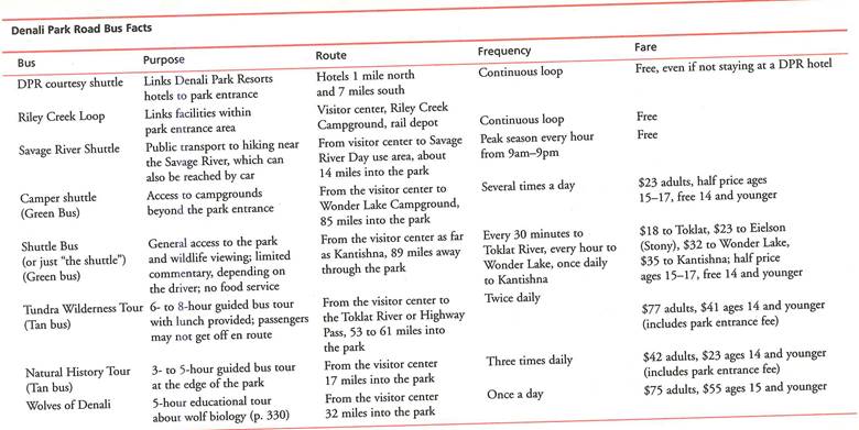
Denali bus facts
Optional Bear viewing
I wanted to do the katmai bear viewing (bears seating on top of fall and catching the salmons as they jump up) but ended up doing a day bear view trip, which was also great. Info below
Bear viewing trip - http://www.flyrusts.com/bear-viewing/lake-clark-national-park.html
Lake Clark National Park Bear Viewing
Alaska experience of a lifetime. After an hour and ten minute thrilling flightseeing tour from Anchorage to Lake Clark National Park and Preserve, you will land at Redoubt Mountain Lodge. Knowledgeable bear viewing guides escort you by boat to lakeside areas where bears feed on spawning wild Alaska salmon.
Situated at the headwaters of Bristol Bay, Lake Clark National Park and Preserve is an epitome of the Alaska wilderness landscape. At four million acres, the Park encompasses volcanoes, jagged mountains, glaciers, wild rivers, waterfalls and diverse Alaska wildlife populations.
2014 promises to be an amazing year for the bears of Lake Clark National Park. Our 2013 season welcomed many new faces, including numerous cubs, to the Crescent River Valley. Second year bears are so entertaining because the cubs begin applying the mother bears lessons on life. Watch as they clumsily pursue salmon and confront other bears during this learning and maturing phase. You can be fortunate enough to be able to observe this exciting time in a great setting inside one of the nations most inaccessible National Parks!
Flight Pattern
Depart from Lake Hood Sea Plane Harbor in Anchorage and fly southwest over Cook Inlet and the tundra-covered hills of the western Alaska interior. Watch for the Chigmit Mountains, where Alaska and Aleutian Ranges meet, and two active volcanoes Mt. Redoubt and Mt. Iliamna before landing in Crescent Lake, Lake Clark National Park and Preserve.
The Lake Clark Bear Viewing experience:
- Intimate, 70 minute scenic flight seeing tour from Anchorage
- Up-close bear viewing in Lake Clark National Park from a covered pontoon boat
- Homemade lunch in the rustic lodge located in Lake Clark National Park
- Observe grizzly bears fishing for salmon; frolicking in water
Your Lake Clark National Park Bear Viewing tour includes:
- A window seat and 2-way headset
- Detailed knowledge (and personality) of an Alaska bush pilot
- Rusts meticulous attention to comfort and safety
- Summertime courtesy shuttle from the Anchorage airport and many Anchorage hotels
Food recommendations
Sweard
· Rays waterfront (we got a lot of recommendations from people). We went there as I wanted to experience fresh seafood. Expensive restaurant and in my opinion really not worth it.
Talkeenta
· Mountain High Pizza Pie
Alyeska
· Chair 5 pizza place
Anchorage
·
Spenard roadhouse really enjoyed it
·
Pho lena